
The Panch Kedar Yatra takes pilgrims through a spiritually enriching journey across five sacred temples dedicated to Lord Shiva in the Garhwal Himalayas. The traditional route typically starts at Kedarnath, leading to Tungnath, Rudranath, Madhyamaheshwar, and concluding at Kalpeshwar. The trek offers a panoramic view of the Himalayan peaks, pristine meadows, and dense forests. Pilgrims navigate through challenging terrains, picturesque villages, and ancient pilgrimage sites, following an awe-inspiring path steeped in Hindu mythology. While specific routes may vary, the Panch Kedar Yatra map outlines a transformative expedition, combining physical endurance with spiritual exploration amid the majestic Himalayan landscape.
Panch Kedar Package Char Dham Yatra Adi Kailash yatra
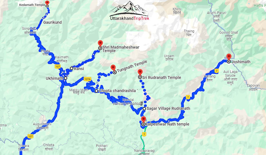
Trekking Distance During Panch Kedar Trek
| Kedarnath Dham | Gaurikund to kedarnath Dham & back to Gaurikund | 36 Km (18 Km Per Side) |
| Madmaheshwar Temple | Ransi Village to Madmaheshwar and back to Ransi village | 32 Km (16 Km Per Side) |
| Tungnath Temple | Chopta to Tungnath and Back to Chopta | 7 Km (3.5 Km Per Side) |
| Rudranath Temple | Sagar- Panar Bugyal- Rudranath and back to Sagar Village | 34 Km (17 Km Per Side) |
Note :- Total Trekking distance of approximately 109 kilometers
Driving Distance Rishikesh to Rishikesh
| Rishikesh to Guptkashi | 180 km (7-8 hrs) |
| Guptkashi to Gaurikund | 30 Km (1-2 hrs) |
| Gaurikund to Ransi Village | 70 Km (3-4 hrs) |
| Ransi Village to Chopta | 50 km, 2-2.5 hrs |
| Chopta to Sagar Village | 35 km, (1-1.5 hrs) |
| Sagar Village to Kalpeshwar Temple and Joshimath | 55 km, 2-3 hrs |
| Joshimath to Badrinath and back to joshimath | 40+ 40 = 80 Km ( 3-4 Hrs) |
| Joshimath to Rishikesh | 250 km, (7-8 hrs) |
How to Reach Panch Kedar
| Delhi | Rishikesh | 225km/5-6 hrs approx |
| Rishikesh | Guptkashi | 180km/6-7 hrs approx |
How to Reach Kedarnath from Delhi :- click Here