
Comming Soon……
Category: Uttarakhand
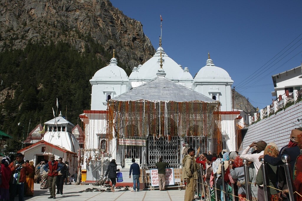
Gangotri
Gangotri Temple is one of the most sacred pilgrimage sites in India and an integral part of the Char Dham Yatra. Located in the Uttarkashi district of Uttarakhand at an altitude of about 3,100 meters, Gangotri marks the spiritual origin of River Ganga, revered as Goddess Ganga.
Set amidst towering Himalayan peaks, dense forests, and the roaring Bhagirathi River, Gangotri offers a deeply peaceful and divine atmosphere.
Significance of Gangotri Dham
According to Hindu mythology, King Bhagirath performed intense penance to bring Goddess Ganga down from heaven to cleanse the souls of his ancestors. Lord Shiva captured the mighty river in his matted locks to soften her descent to Earth. The river flows here as Bhagirathi, later becoming Ganga after meeting the Alaknanda at Devprayag.
The Gangotri Temple was built in the 18th century by Amar Singh Thapa, a Gorkha commander.
Gangotri Temple Opening & Closing
- Opening Time: April/May (on Akshaya Tritiya)
- Closing Time: October/November (on Bhai Dooj)
- Winter Abode: Mukhyamath (Mukhba Village)
Dates are announced every year by the temple authorities.
Major Attractions Near Gangotri
- Bhagirath Shila – Rock where King Bhagirath meditated
- Pandava Gufa – Cave associated with the Pandavas
- Surya Kund – Sacred waterfall near the temple
- Gaumukh Glacier – Actual source of River Ganga (trek required)
- Harsil Valley – Scenic Himalayan valley near Gangotri
How to Reach Gangotri
By Road:
Rishikesh / Haridwar → Uttarkashi → Gangotri
By Rail:
Nearest railway station – Rishikesh (250 km)
By Air:
Nearest airport – Jolly Grant Airport, Dehradun (272 km)
Best Time to Visit Gangotri
The best time to visit Gangotri is May to June and September to October. The temple remains closed during winter due to heavy snowfall. July–August is risky due to monsoon conditions.
Important Travel Tips for Gangotri Yatra
- Mandatory Char Dham Yatra registration
- Carry warm clothing even in summer
- Avoid bathing directly in the icy river; use designated kunds
- Respect temple rituals and local customs
- Check weather and road conditions regularly
Why Visit Gangotri Dham?
Gangotri is not just a pilgrimage—it is the spiritual birthplace of the Ganga, symbolizing purity, salvation, and divine grace. The serene Himalayan setting and sacred legends make Gangotri an essential and soul-cleansing journey.
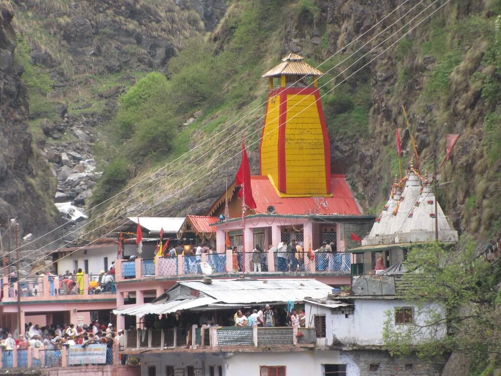
Yamunotri
Yamunotri Temple is the westernmost shrine of the Char Dham Yatra and is dedicated to Goddess Yamuna. Located in the Uttarkashi district of Uttarakhand at an altitude of about 3,293 meters, Yamunotri marks the sacred origin of the River Yamuna and is surrounded by pristine Himalayan landscapes.
A visit to Yamunotri is believed to protect devotees from untimely death and cleanse sins through the blessings of Goddess Yamuna.
Significance of Yamunotri Dham
According to Hindu mythology, Goddess Yamuna, the daughter of Surya (Sun God) and sister of Yama (God of Death), resides here. It is believed that bathing in the Yamuna absolves devotees from the fear of death and grants spiritual purification.
The temple was built by Maharani Guleria of Jaipur in the 19th century and later renovated due to natural calamities.
Yamunotri Temple Opening & Closing
- Opening Time: April/May (on Akshaya Tritiya)
- Closing Time: October/November (on Yama Dwitiya / Bhai Dooj)
Dates are announced every year by the temple committee.
Yamunotri Yatra Route
- Base Point: Janki Chatti
- Trek Distance: ~6 km (one way)
- Options Available:
- Trekking
- Pony / Mule
- Palki
Major Attractions Near Yamunotri
- Surya Kund – Hot water spring used for cooking prasad
- Divya Shila – Sacred rock near the temple
- Hanuman Chatti – Confluence and stopover point
- Kharsali Village – Known for ancient Shani Dev Temple
How to Reach Yamunotri
By Road:
Rishikesh / Haridwar → Dehradun → Barkot → Janki Chatti
By Rail:
Nearest railway station – Dehradun (172 km)
By Air:
Nearest airport – Jolly Grant Airport, Dehradun (196 km)
Best Time to Visit Yamunotri
The best time to visit Yamunotri is May to June and September to October. July–August should be avoided due to heavy monsoon rains and landslides.
Important Travel Tips for Yamunotri Yatra
- Complete Char Dham Yatra registration in advance
- Carry warm clothing and rain gear
- Walk slowly during the trek to avoid exhaustion
- Use proper trekking shoes with good grip
- Follow local weather and safety advisories
Why Visit Yamunotri Dham?
Yamunotri offers a peaceful and spiritually uplifting start to the Char Dham Yatra. The serene environment, sacred hot springs, and divine presence of Goddess Yamuna make this dham a place of purity, devotion, and inner calm.
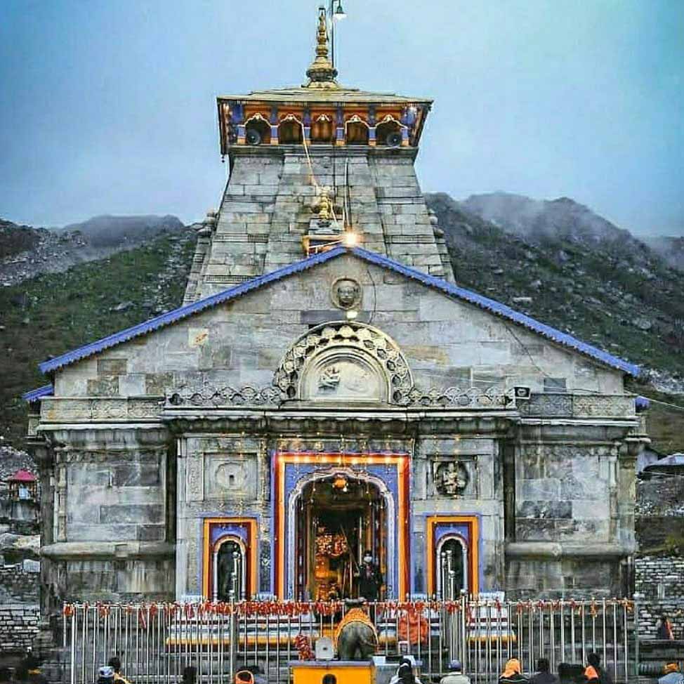
Kedarnath
Kedarnath Temple is one of the holiest Hindu pilgrimage sites and a central part of the Char Dham Yatra. Situated at an altitude of about 3,583 meters in the Rudraprayag district of Uttarakhand, the temple is dedicated to Lord Shiva and is revered as one of the 12 Jyotirlingas in India.
Surrounded by snow-clad Himalayan peaks and located near the Mandakini River, Kedarnath offers a deeply spiritual and awe-inspiring experience.
Significance of Kedarnath Dham
According to Hindu mythology, after the Mahabharata war, the Pandavas sought Lord Shiva’s forgiveness. Shiva took the form of a bull and hid in Kedarnath; when discovered, he dived into the earth, leaving his hump at Kedarnath. This is why the temple worships the hump-shaped Jyotirlinga.
The temple was revived by Adi Shankaracharya in the 8th century, and his samadhi lies behind the temple.
Kedarnath Temple Opening & Closing
- Opening Time: April/May (on Akshaya Tritiya)
- Closing Time: October/November (on Bhai Dooj)
- Winter Abode: Omkareshwar Temple, Ukhimath
Exact dates are announced annually by the temple committee.
Kedarnath Yatra Route
- Base Point: Gaurikund
- Trek Distance: ~16 km (one way)
- Options Available:
- Trekking
- Pony / Mule
- Palki
- Helicopter services (from Phata, Guptkashi, Sersi)
Major Attractions Near Kedarnath
- Bhairavnath Temple – Protector deity of Kedarnath
- Gandhi Sarovar (Chorabari Tal) – Glacial lake near the temple
- Vasuki Tal – High-altitude sacred lake
- Triyuginarayan Temple – Mythological wedding site of Lord Shiva and Parvati
How to Reach Kedarnath
By Road:
Rishikesh / Haridwar → Rudraprayag → Guptkashi → Sonprayag → Gaurikund
By Rail:
Nearest railway station – Rishikesh (216 km)
By Air:
Nearest airport – Jolly Grant Airport, Dehradun (238 km)
Best Time to Visit Kedarnath
The best time to visit Kedarnath is May to June and September to October. July and August are risky due to heavy monsoon rainfall and landslides.
Important Travel Tips for Kedarnath Yatra
- Mandatory Char Dham Yatra registration
- Carry warm clothes and rain protection
- Acclimatize properly due to high altitude
- Start the trek early in the morning
- Follow local administration and weather advisories
Why Visit Kedarnath Dham?
Kedarnath is not just a pilgrimage—it is a journey of faith, endurance, and divine connection. The powerful presence of Lord Shiva amid the Himalayas makes Kedarnath one of the most spiritually uplifting destinations in India.
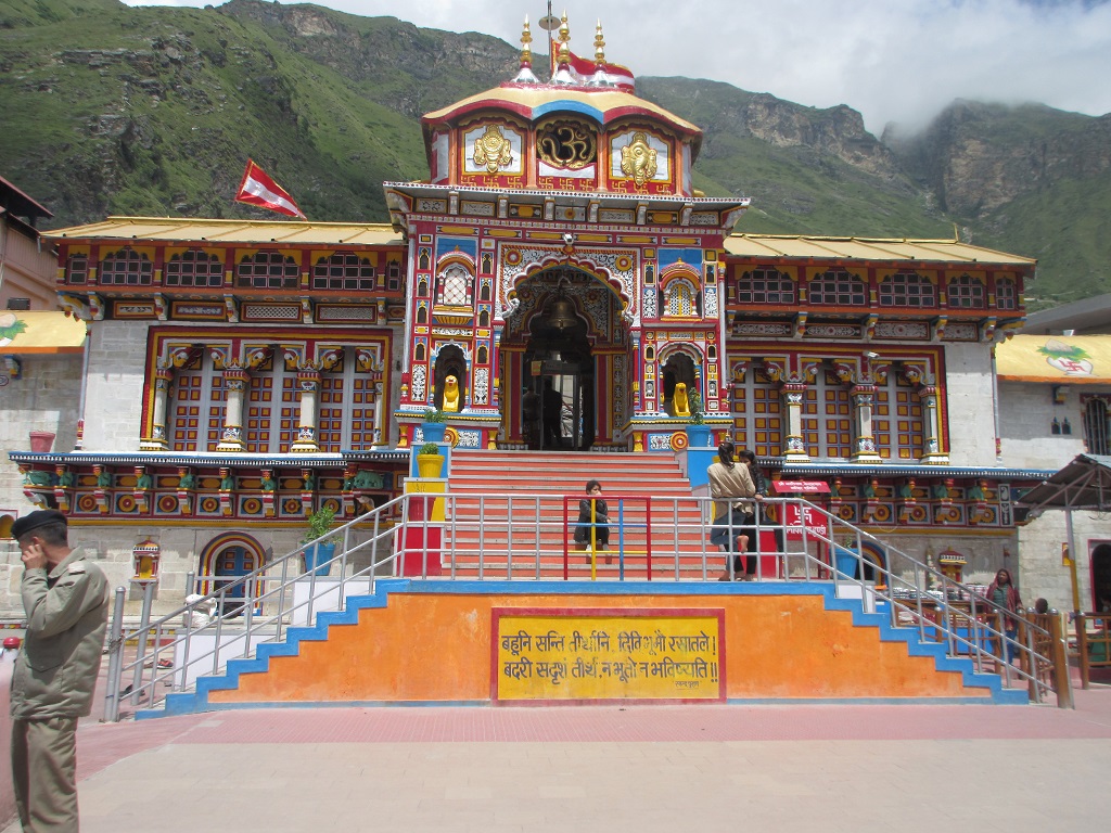
Badrinath
Badrinath Temple is one of the most revered pilgrimage sites in India and a vital part of the Char Dham Yatra. Located in the Chamoli district of Uttarakhand, this sacred temple is dedicated to Lord Vishnu and lies on the banks of the holy Alaknanda River, surrounded by the majestic Nar and Narayan mountain ranges.
Badrinath is not just a destination—it is a spiritual experience that draws devotees, saints, and travelers from across the world.
Significance of Badrinath Dham
According to Hindu scriptures, Lord Vishnu meditated here for thousands of years, while Goddess Lakshmi took the form of a Badri tree to protect him—giving the place its name Badrinath. The temple holds immense importance in Vaishnavism and is also one of the 108 Divya Desams mentioned in Tamil scriptures.
Adi Shankaracharya re-established the temple in the 8th century, reviving its spiritual prominence.
Badrinath Temple Opening & Closing
- Opening Time: April/May (on Akshaya Tritiya)
- Closing Time: October/November (on Vijayadashami)
- Winter Abode: Omkareshwar Temple, Ukhimath
Note: Dates are announced every year by the Badrinath–Kedarnath Temple Committee.
Major Attractions Near Badrinath
- Tapt Kund – Natural hot water spring for ritual bathing before darshan
- Neelkanth Peak – Sacred peak associated with Lord Shiva
- Mana Village – The last Indian village near the Indo-Tibet border
- Vasudhara Falls – A serene waterfall with mythological importance
- Charan Paduka – Footprints believed to belong to Lord Vishnu
How to Reach Badrinath
By Road:
Well connected via Rishikesh, Haridwar, Joshimath, and Rudraprayag.
By Rail:
Nearest railway station – Rishikesh (295 km)
By Air:
Nearest airport – Jolly Grant Airport, Dehradun (310 km)
Best Time to Visit Badrinath
The ideal time to visit Badrinath is May to June and September to October, when the weather is pleasant and the roads are clear. July–August should be avoided due to monsoon landslides.
Travel Tips for Badrinath Yatra
- Carry warm clothing even in summer
- Complete Char Dham registration before travel
- Acclimatize properly to avoid altitude sickness
- Start journeys early in the day due to mountain weather
Why Visit Badrinath Dham?
Badrinath offers a rare combination of spiritual depth, ancient history, and Himalayan beauty. Whether you seek divine blessings, inner peace, or a connection with India’s sacred heritage, Badrinath Dham promises a truly transformative journey.
Unveiling the Mystique of Kedarnath’s Lesser-Known Neighbourhoods
Kedarnath, one of the most revered pilgrimage sites in the Indian Himalayas, has been attracting devotees for centuries. While many flock to the temple town, there are hidden gems waiting to be explored in its lesser-known neighbourhoods. In this article, we will delve into the uncharted territories surrounding Kedarnath, where unique stays, trekking routes, and local experiences offer a tranquil retreat from the bustling temple town.</p>nn<p>Located just a few kilometers away from Kedarnath, the villages of Ramani and Sitapur are nestled in the heart of the Garhwal Himalayas. These quaint hamlets offer a glimpse into rural life in Uttarakhand, where traditional houses, verdant fields, and sparkling streams create an idyllic atmosphere.</p>nn<ul>nt<li><strong>Trek to Ramani</strong>: A moderately difficult trek from Kedarnath, this route offers breathtaking views of the surrounding mountains and valleys.</li>nt<li><strong>Explore Sitapur</strong>: Wander through the narrow streets of this charming village, where ancient temples, local shops, and traditional eateries await discovery.</li>nt<li><strong>Visit the Village of Phata</strong>: Located near Ramani, this picturesque village boasts stunning views of the Mandakini River and offers a glimpse into rural life.</li>n</ul>nn<p>For those seeking an authentic experience, unique stays in these neighbourhoods offer a chance to immerse oneself in local culture. Some options include:</p>nn<ul>nt<li><strong>Homestays</strong>: Live with local families and experience traditional Garhwali hospitality.</li>nt<li><strong>Eco-Lodges</strong>: Stay in environmentally friendly accommodations that blend seamlessly into the surrounding landscape.</li>nt<li><strong>Camping</strong>: Pitch a tent under the stars, surrounded by nature’s splendour.</li>n</ul>nn<p>When planning your trip to these neighbourhoods, keep the following tips in mind:</p>nn<ul>nt<li><strong>Weather</strong>: Be prepared for unpredictable weather conditions, especially during the monsoon season.</li>nt<li><strong>Altitude Sickness</strong>: Acclimatize yourself to the high altitude by taking it easy on arrival and staying hydrated.</li>nt<li><strong>Local Transportation</strong>: Use local transportation services or trek to explore these neighbourhoods.</li>n</ul>nn<p>Budget accordingly with estimated costs for:</p>nn<ul>nt<li><strong>Accommodation</strong>: ₹500-₹2,000 per night (approximately $6-$25 USD)</li>nt<li><strong>Food</strong>: ₹100-₹300 per meal (approximately $1.50-$4 USD)</li>nt<li><strong>Transportation</strong>: ₹200-₹500 per ride (approximately $3-$7 USD)</li>n</ul>nn<p>We spoke with local guides and residents who shared their insights on exploring these neighbourhoods:</p>nn<blockquote>n<p>"Be sure to try the local cuisine, especially the Garhwali thalis, which are a delicious blend of traditional dishes."</p>nn<p>"Trekking in the mornings is best, as the weather is generally clearer, and the views more breathtaking."</p>nn<p>"Respect local customs and traditions when interacting with villagers."</p>n</blockquote>nn<p>The lesser-known neighbourhoods surrounding Kedarnath offer a tranquil retreat from the bustling temple town. By exploring these hidden gems, you’ll discover unique stays, trekking routes, and local experiences that will leave you enchanted. So pack your bags, grab your trekking poles, and embark on an unforgettable journey through the uncharted territories of Uttarakhand.</p>n”,
Kafni Glacier
The Kafni Glacier is located in the Kumaon Himalayas in the state of Uttarakhand, India. It is one of the major glaciers in the region and a significant source of the Kafni River, a tributary of the Pindar River. The glacier is situated in the upper reaches of the Kumaon Himalayas, near the Nanda Devi National Park.
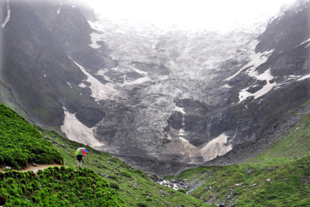
Trekking to the Kafni Glacier is a popular activity for adventure enthusiasts and nature lovers. The trek offers stunning views of snow-capped peaks, lush green valleys, and pristine alpine meadows. The route to the glacier passes through picturesque villages, dense forests, and high-altitude landscapes, providing an unforgettable experience for trekkers.
The Kafni Glacier trek usually starts from the village of Loharkhet and takes around 5-7 days to complete round trip, depending on the pace and route taken. Trekkers usually camp at various scenic spots along the way, soaking in the beauty of the Himalayan landscape.
Glacier In Uttarakhand

How To Reach Sankri
Sankri is a picturesque village located in the Uttarkashi district of the Indian state of Uttarakhand. It serves as a…

Unveiling the Mystique of Kedarnath’s Lesser-Known Neighbourhoods
Kedarnath, one of the most revered pilgrimage sites in the Indian Himalayas, has been attracting devotees for centuries. While many…
Kedarnath Yatra from Delhi (04D/3N)
Yatra Overview
- Region :- Garhwal (Uttarakhand)
- Duration :- 04 Days / 3 Night
- Max Altitude :- 3583 m.
- Approx Trekking :- 16 Km (Per Side)
- Reporting Time & Place :- ISTB Kashmiri Gate Side at 0900 Hr
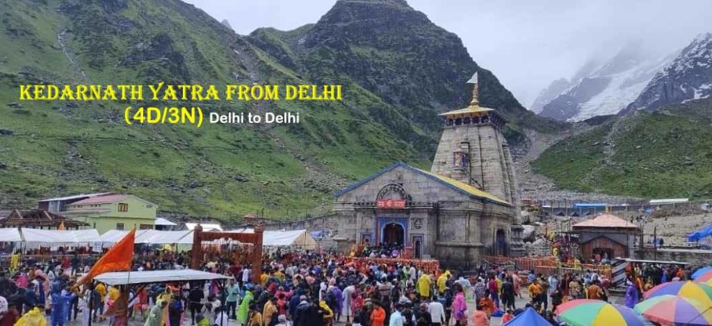
Kedarnath Yatra from Delhi Overview
spiritual journey of the Kedarnath Yatra from Delhi, a transformative pilgrimage to the majestic Himalayas. Begin with a road or train trip to Haridwar or Rishikesh, followed by a scenic drive to Gaurikund. From there, ascend to the revered Kedarnath Temple, cradled amidst snow-clad peaks. This spiritual odyssey seamlessly blends devotion with nature’s grandeur, guiding pilgrims through picturesque landscapes and pristine rivers. Upon reaching Kedarnath, the temple’s divine ambiance inspires profound spiritual experiences. The return to Delhi becomes a time for introspection, leaving pilgrims with a deep sense of peace and a profound connection forged in the heart of the awe-inspiring Himalayas.
Kedarnath Yatra from Delhi Highlights
- Spiritual Epicenter:
- Kedarnath, a Char Dham shrine, holds deep spiritual significance with its ancient temple dedicated to Lord Shiva.
- Scenic Route:
- Breathtaking landscapes unfold through a scenic journey from Haridwar/Rishikesh to Gaurikund.
- Challenging Trek:
- Ascend to Kedarnath with a challenging trek or alternative transport like ponies or palanquins.
- Sacred Rituals:
- Pilgrims engage in sacred rituals at Kedarnath Temple, seeking divine blessings from Lord Shiva.
- Divine Atmosphere:
- Kedarnath’s spiritual ambiance, surrounded by snow-clad peaks, enhances the pilgrimage’s serenity.
Kedarnath Yatra from Delhi Itinerary
Day 1 : Delhi — Haridwar – Guptkashi
The drive from Delhi to Guptkashi typically takes around 6-7 hours. Upon reaching Guptkashi, check into your accommodation and take some time to rest. Guptkashi, nestled in the Himalayan region, provides a serene backdrop for your pilgrimage. The town is a significant stop en route to Kedarnath and holds its own religious importance.
Day 2 : Guptkashi — Kedarnath Dham
This day is dedicated to the main pilgrimage to Kedarnath.Start early in the morning, as it involves a journey by road and a yatra to Kedarnath.Drive to Sonprayag, which is the base point for the trek to Kedarnath.From Sonprayag, either trek for around 16 km or hire a pony/doli (palanquin) to reach Kedarnath.Visit the sacred Kedarnath Temple and seek blessings.
.Overnight stay in Shri Kedarnath Dham
Day 3 : Kedarnath Dham Guptkashi
Morning after Pooja & breakfast, you can check out of Kedarnath hotel start your journey back to Sonprayag. Our driver will be there at designated place which was discussed with you. Drive back to Guptkashi hotel for night stay.
Day 4 : Guptkashi — Delhi Via Rishikesh
After breakfast, check out from the hotel in Guptkashi.Drive back to Dehli, which takes around 10-11 hours.
| Inclusions | Exclusions |
| – Transport from Delhi to Delhi – Accommodation in hotels/GMVN guesthouse/home stay as per the package, – Pure Vegetarian food during the trip (as per the meals mentioned) – Meal Breakfast & Dinner at hotel | – Any medical expense in the event of bad health, – Any insurance for traveler, his belongings, or any item/service of the trip, – Any other item which is not specifically mentioned in the list of inclusions above. |
More Package :- Char Dham Yatra :: Panch Kedar Yatra :: Do Dham Yatra :: Kedarnath Yatra
How To Reach Mindrolling Monastery
To reach Mindrolling Monastery, located in Dehradun, Uttarakhand, here’s how you can get there:
By Air
- Nearest Airport: Jolly Grant Airport (Dehradun Airport) is about 30 km away. From the airport, you can hire a taxi or use ride-sharing services to reach the monastery.
By Train
- Nearest Railway Station: Dehradun Railway Station is approximately 6 km from Mindrolling Monastery. You can take a taxi, auto-rickshaw, or local bus from the station to the monastery.
By Road
- By Car: If you’re driving, Mindrolling Monastery is well-connected by road. It’s about a 15-20 minute drive from the city center.
- Local Transport: You can also use local buses or taxis that frequent the area.
Tips
- Visiting Hours: Check the monastery’s visiting hours before you go, as they can vary.
- Dress Code: Dress modestly, as it is a place of worship.
- Photography: Be respectful when taking photos, especially during prayers or ceremonies.
Enjoy your visit to Mindrolling Monastery!
How To Reach Corbett Museum
Reaching Corbett Museum in Kaladhungi, Uttarakhand, is quite straightforward. Here’s how you can get there:
By Road
- From Ramnagar:
- Distance: Approximately 30 km (about 45 minutes to 1 hour by car).
- Directions: Take the Ramnagar-Kaladhungi road, which is well-marked and leads directly to the museum.
- Transportation: You can hire a taxi, use local buses, or drive your own vehicle.
- From Nainital:
- Distance: About 50 km (around 1.5 to 2 hours by road).
- Route: Head towards Kaladhungi via the Nainital-Ramnagar road. The journey is scenic and offers beautiful views of the surrounding hills.
By Rail
- Nearest Railway Station: Ramnagar Railway Station is the closest, located approximately 30 km from the museum.
- Train Services: Regular trains operate from cities like Delhi and Lucknow to Ramnagar.
- From the Station: Once you arrive, you can hire a taxi or take a local bus to Kaladhungi.
By Air
- Nearest Airport: Pantnagar Airport is around 80 km away.
- Flight Services: Limited flights operate from major cities like Delhi to Pantnagar.
- Transportation: From the airport, you can hire a taxi to Kaladhungi.
Nearby Attractions
- After visiting the museum, consider exploring Jim Corbett National Park or Corbett Waterfall, both close by.